


 Feed
Feed Scan with QR Code Reader
 mobi
mobi- Advertise / Donate
Welcome !
Newquay weather receives over 1000 vistors per day winter time, rising to over 3000 to 4000 or more in the summer, including visitors from all over the world.
Please help support this site

Your business

Via Paypal
- Accommodation
Hotels, B&B's and Caravan and Camping Sites

Porth Sands - Luxury beach accommodation wth beach facing balconies, a golden sandy beach making it the perfect place to idle away the hours- swimming, body boarding, sunbathing and paddling.
- Food
Restaurants, Cafe's, Takeaways

Pachanga - Pachanga Authentic Mexican Since 2016 we've been re-creating dishes that are part of our cultural heritage using techniques that are unique to Mexico. We use mostly Mexican, local & organic produce in our dishes & drinks
- Charity Events
Charity Events - Max 3 free ads
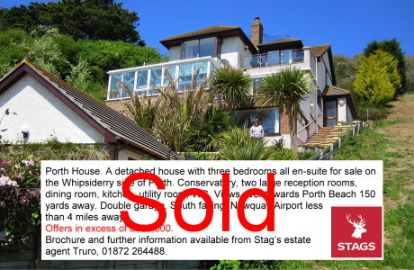
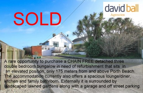
For a Free Charity Ad Here, please contact me- - Houses for Sale
Houses for Sale
Advertise your house for sale here and help support this site.
Small photo, text + link to agents for a One off ₤25. Please contact me.Advertise your house for sale here
- Local Services
Shops, Services etc

Body BounceBody Bounce bouncy castle park in Newquay. Great fun, fantastically priced and we are open during the warmer months weather depending. (Postcode for SATNAV: TR7 2QF). Body Bounce also provides private bouncy castle hire. Check out our full range at Body-Bounce
UK Earthquakes and European Map
New, Earthquake Seismogram page from Carnmenellis, Cornwall Here
| UK Earthquakes in the last 60 days | ||||
|---|---|---|---|---|
| Updated: 21/02/2025 15:56 | ||||
| Epicenter Near | Magnitude | Distance to Epicenter | Local Time | Link to Map |
| KIPPEN,STIRLING | 1.3 | 396 mi (637 km) | 18/02/2025 20:12 | Map |
| KILMORE,ARGYLL & BUTE | 1.1 | 411 mi (661 km) | 15/02/2025 17:54 | Map |
| LITTON,NORTH YORKSHIRE | 1.1 | 285 mi (458 km) | 15/02/2025 15:58 | Map |
| LITTON,NORTH YORKSHIRE | 0.2 | 285 mi (459 km) | 15/02/2025 15:58 | Map |
| ISLAY,ARGYLL & BUTE | 1.1 | 375 mi (604 km) | 12/02/2025 03:36 | Map |
| BOYTON,CORNWALL | 0.9 | 34 mi (55 km) | 09/02/2025 16:18 | Map |
| KNUTSFORD,CHESHIRE | 1.5 | 230 mi (370 km) | 09/02/2025 14:25 | Map |
| IRISH SEA | 0.7 | 178 mi (287 km) | 07/02/2025 00:24 | Map |
| MALVERN,WORCESTERSHIRE | 2.0 | 166 mi (267 km) | 05/02/2025 11:44 | Map |
| GLENLONAN,ARGYLL/BUTE | 0.5 | 412 mi (664 km) | 05/02/2025 08:27 | Map |
| GLENLONAN,ARGYLL/BUTE | 1.6 | 413 mi (664 km) | 05/02/2025 08:09 | Map |
| GLENLONAN,ARGYLL/BUTE | 2.2 | 413 mi (665 km) | 05/02/2025 03:03 | Map |
| CENTRAL NORTH SEA | 3.5 | 535 mi (862 km) | 03/02/2025 00:05 | Map |
| BRADLEY,N YORKSHIRE | 0.5 | 275 mi (443 km) | 01/02/2025 21:28 | Map |
| RATLINGHOPE,SHROPSHIRE | 0.5 | 175 mi (282 km) | 01/02/2025 13:52 | Map |
| BYRNESS,NORTHUMBERLAND | 0.8 | 354 mi (570 km) | 30/01/2025 00:47 | Map |
| CENTRAL NORTH SEA | 3.4 | 533 mi (858 km) | 27/01/2025 05:23 | Map |
| DALMALLY,ARGYLL & BUTE | 0.5 | 418 mi (673 km) | 26/01/2025 06:13 | Map |
| SOUTHERN NORTH SEA | 3.0 | 384 mi (619 km) | 26/01/2025 04:32 | Map |
| NORTHERN NORTH SEA | 2.8 | 706 mi (1136 km) | 22/01/2025 09:12 | Map |
| TAIN,HIGHLAND | 0.9 | 511 mi (822 km) | 21/01/2025 16:37 | Map |
| LLANGURIG,POWYS | 0.4 | 148 mi (238 km) | 19/01/2025 20:42 | Map |
| DORRINGTON,SHROPSHIRE | 1.7 | 179 mi (289 km) | 14/01/2025 20:58 | Map |
| IRISH SEA | 1.3 | 164 mi (265 km) | 13/01/2025 20:35 | Map |
| DORRINGTON,SHROPSHIRE | 1.9 | 179 mi (288 km) | 13/01/2025 17:03 | Map |
| BLAIRLOGIE,STIRLING | 1.2 | 399 mi (642 km) | 10/01/2025 13:13 | Map |
| HARTSOP,CUMBRIA | 0.9 | 297 mi (478 km) | 09/01/2025 22:46 | Map |
| SKELTON,CUMBRIA | 1.4 | 312 mi (501 km) | 08/01/2025 18:51 | Map |
| IRISH SEA | 1.3 | 236 mi (380 km) | 08/01/2025 02:48 | Map |
| ACHNASHELLACH,HIGHLAND | 0.7 | 487 mi (784 km) | 07/01/2025 20:33 | Map |
| SANDBANK,ARGYLL & BUTE | 0.2 | 385 mi (619 km) | 06/01/2025 10:39 | Map |
| KINLOCH,HIGHLAND | 2.9 | 430 mi (693 km) | 05/01/2025 20:44 | Map |
| GREATGATE,STAFFS | 1.5 | 220 mi (355 km) | 04/01/2025 14:17 | Map |
| TINTAGEL,CORNWALL | 0.2 | 22 mi (35 km) | 03/01/2025 04:47 | Map |
| BUTE,ARGYLL & BUTE | 0.4 | 373 mi (601 km) | 02/01/2025 13:36 | Map |
| MELBOURNE,DERBYSHIRE | 0.7 | 228 mi (367 km) | 01/01/2025 15:16 | Map |
| NEWPORT,SHROPSHIRE | 1.8 | 199 mi (320 km) | 28/12/2024 19:53 | Map |
| BURRY PORT,CARMARTH | 0.4 | 93 mi (150 km) | 28/12/2024 12:13 | Map |
| SUTTON COLDFIELD,WMD | 0.5 | 203 mi (327 km) | 28/12/2024 03:57 | Map |
| CORRIS,GWYNEDD | 1.0 | 162 mi (260 km) | 26/12/2024 15:33 | Map |
| BRAMPTON,CUMBRIA | 1.2 | 328 mi (527 km) | 26/12/2024 13:39 | Map |
| WIGTON,CUMBRIA | 0.2 | 311 mi (500 km) | 24/12/2024 05:50 | Map |
42 UK Earthquakes in the last 60 days.
Reproduced with the permission of the British Geological Survey © NERC. All rights Reserved.
Based upon KML Data Feeds, with the permission of the British Geological Survey.
Check out the UK Earthquake Timeline 1970 to Present Day Here from the British Geological Survey
Cornwall Map of Historical Earthquakes
Local Earthquakes |
|
July 2014
The higest level of detections in the last decade is set to be registered for 2014 with 100 earthquakes recorded in the first 3 months of the year and 149 in total up until July.
This compares to 154 in 2013, 64 in 2006 and 111 in 2005. |
| 17:26 on 23rd July 2014 - Jersey - 3.2 magnitude |
| 12:54 on 11th July 2014 - Jersey - 4.2 magnitude |
| 10th November 1996 - Centred on Mounts Bay, near Penzance. 3.8 on the Richter Scale |
| 25 February and 12 June 1981 Here Constantine and Liskard |
| ------------- |
|
The average recurrence the UK may expect can be estimated as follows: an earthquake of 3.7 or larger every 1 year an earthquake of 4.7 or larger every 10 years an earthquake of 5.6 or larger every 100 years. |
Cornwall Geology Map -Sorry you will have to zoom in.
Europe RSS Feed
Unable to open RSS Feed $XMLfilename with error HTTP ERROR: 404, exiting

)